Environmental IntelligenceTurning Data into Resilient Water & Climate Solutions
Explore Our Environmental Intelligence Capabilities
We combine expertise in water and environmental engineering with digital tools to optimize processes in water utilities and organizations
Hydrologic and hydraulic analysis, stormwater drainage capacity assessment
Data management and custom tools for stormwater applications, digital twins
CSO/SSO, dual drainage, stormwater quality assessment, engineering design

Stormwater Modeling
Stormwater Modeling
Hydrologic and hydraulic analysis, stormwater drainage capacity assessment
Data management and custom tools for stormwater applications, digital twins
CSO/SSO, dual drainage, stormwater quality assessment, engineering design

Water Quality & Pollution Management
Bacteria, nutrient, and sediment TMDL development and allocation
Pollutant fate & transport modeling (surface and groundwater)
Non-point source load estimation and reduction scenario analysis
Water Quality & Pollution Management
Bacteria, nutrient, and sediment TMDL development and allocation
Pollutant fate & transport modeling (surface and groundwater)
Non-point source load estimation and reduction scenario analysis
1D/2D flood simulation and modeling, watershed management
Green infrastructure, nature-based solutions, climate resilience and adaptation
Flood risk assessment, AI-powered flood warning and forecasting, regulatory programs

Floodplain Management
Floodplain Management
1D/2D flood simulation and modeling, watershed management
Green infrastructure, nature-based solutions, climate resilience and adaptation
Flood risk assessment, AI-powered flood warning and forecasting, regulatory programs

Hydropower Feasibility Studies
Long-term hydrologic study using remote-sensed topographic, land use and rainfall records
Flow-duration and energy-duration curves, site identification and optimization for impoundment- and run-of-river type plants
Modeling and mapping of inundation zones and critically affected settlement areas
Hydraulic modeling and analysis, detailed engineering design for water mains
Operational analysis for fire-flow, valve criticality, flushing, transient pressure and water age
NRW and leakage management strategies, pump scheduling and optimization, multi-species quality modeling

Water Distribution Systems Planning
Water Distribution Systems Planning
Hydraulic modeling and analysis, detailed engineering design for water mains
Operational analysis for fire-flow, valve criticality, flushing, transient pressure and water age
NRW and leakage management strategies, pump scheduling and optimization, multi-species quality modeling

Sanitation and Waste Management
Feasibility studies, policy and advocacy support for sanitation governance
Field surveys and service data acquisition, mobile apps for GIS data collection
Digital transformation of municipal sanitation and waste collection services
Sanitation and Waste Management
Feasibility studies, policy and advocacy support for sanitation governance
Field surveys and service data acquisition, mobile apps for GIS data collection
Digital transformation of municipal sanitation and waste collection services
Esri’s ArcGIS Pro integrated models for water and wastewater utilities
Integrated mobile, web and AI-powered applications to support digital transformation
Digital twins for optimized maintenance and decision making by the water and wastewater utilities

Water Modeling and Geospatial Applications
Water Modeling and Geospatial Applications
Esri’s ArcGIS Pro integrated models for water and wastewater utilities
Integrated mobile, web and AI-powered applications to support digital transformation
Digital twins for optimized maintenance and decision making by the water and wastewater utilities

Utility Asset Management
Custom tools for inspection, maintenance, operations, and lifecycle planning
Advanced applications for gauged and remote‑sensed data management
Integrated platforms linking utility operations, hydraulic modeling, inventory, and billing
Utility Asset Management
Custom tools for inspection, maintenance, operations, and lifecycle planning
Advanced applications for gauged and remote‑sensed data management
Integrated platforms linking utility operations, hydraulic modeling, inventory, and billing

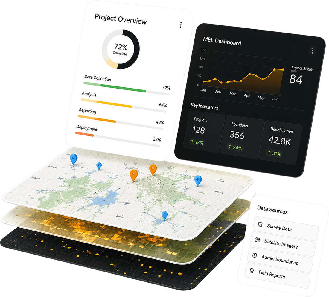
Our Impact & Achievements
We empower our clients to manage stormwater, prevent flooding, ensure clean water, and plan for the impacts of climate change

Digital Twins: We deliver advanced digital twins from parcel to watershed scale, enabling utilities to proactively manage stormwater, mitigate flooding risks, and safeguard water quality.
Geospatial Intelligence: We harness the transformative power of GIS to drive informed planning and decision-making, ensuring resilient water and wastewater infrastructure in the face of climate challenges.
Climate Resilience : Our solutions embed climate impact considerations at their core, providing sustainable, future-ready systems that strengthen community resilience against environmental uncertainties.
Continuous Upgradation : We integrate AI and machine learning to enhance accuracy, productivity, and value, empowering digital systems to process complex environmental data and adapt to evolving climate realities.


Our Approach to Solution
We Create Intelligent Systems that Empower Water Organizations to Thrive in a Changing Climate
Science-First, Context-Driven
Every project begins with a deep understanding of local hydrology, data availability, and stakeholder needs.
We blend ground data with satellite analytics to ensure accuracy, even in data-scarce regions.
Trusted, Transparent, and Resilient
Fully documented, calibrated, and validated models that withstand regulatory and peer review.
We use open standards so clients retain full model ownership and accessibility.
Capacity Building & Knowledge Transfer
We train local teams, provide user-friendly tools, and leave behind sustainable systems.
We deliver technical manuals and SOPs to preserve knowledge for future staff.

Why Streams Tech?
Proprietary and open‑source stack to match your infrastructure, budget and operational need

Proven Expertise
Deep expertise in environmental consulting, water modeling, and funded software projects

Tailored Solutions
End-to-end, scalable systems designed for unique client needs and digital transformation

Seamless Integration
Fully compatible with ArcGIS and AI-powered tools for advanced analytics and real-time insights

Long-Term Commitment
85% client retention, reflecting reliable, sustainable solutions with ongoing support
Proven Expertise
Deep expertise in environmental consulting, water modeling, and funded software projects
Tailored Solutions
End-to-end, scalable systems designed for unique client needs and digital transformation
Seamless Integration
Fully compatible with ArcGIS and AI-powered tools for advanced analytics and real-time insights
Long-Term Commitment
85% client retention, reflecting reliable, sustainable solutions with ongoing support
Converting Complex Challenges into Proven Success Stories Explore Our Projects

Four Mile Run Watershed Program – SWMM Modeling for Sustainable Stormwater Management
Client:
Northern Virginia Regional Commission (NVRC)
The Four Mile Run program uses an advanced SWMM-based digital twin to manage flooding, assess development impacts, and guide sustainable urban planning in one of Virginia’s most urbanized watersheds
Key Features
- Flood Risk Modeling
- Development Impact Review
- Real-Time Digital Twin
- Stormwater Capacity Analysis
Bacteria TMDL Development for Mattaponi River Watershed
Client:
Virginia Department of Environmental Quality (Virginia DEQ)
Streams Tech developed TMDLs for 14 impaired Mattaponi River streams, using GIS, HSPF modeling, and data analysis to quantify bacteria loads, propose reduction scenarios, and ensure compliance with water quality standards.
Key Features
- Watershed-based hydrologic & water quality modeling.
- Load-reduction recommendations for regulatory compliance.
- GIS-driven assessment of point and non-point bacteria sources.


Stormwater Drainage Master Plan & Flood Mitigation for Freetown, Sierra Leone
Client:

Government of Sierra Leone
Streams Tech developed Freetown’s stormwater master plan, using GIS, field surveys, and modeling to identify flood-prone areas, recommend mitigation measures, and build local capacity for sustainable flood management
Key Features
- Data collection through surveys, flow gages, satellite imagery, and historical records
- Flood risk mitigation using SWMM modeling and floodplain mapping under extreme events
- Infrastructure upgrades with detention facilities and expanded storm drainage networks