GIS Solutions by Streams Tech 123Empowering Decisions with Geospatial Intelligence
Explore Our GIS Capabilities
We offer a full spectrum of GIS services tailored to your needs. Solutions are scalable, secure, and built for real‑world impact
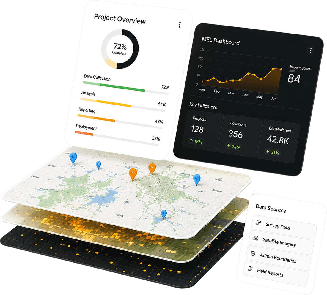
Custom web and mobile GIS applications for data collection, visualization, and reporting
Interactive dashboards with map-based analytics and real-time data feeds
Integration with ArcGIS, QGIS, Google Maps, OpenStreetMap etc.
.jpg&w=3840&q=75)
GIS Application Development
GIS Application Development
Custom web and mobile GIS applications for data collection, visualization, and reporting
Interactive dashboards with map-based analytics and real-time data feeds
Integration with ArcGIS, QGIS, Google Maps, OpenStreetMap etc.

Spatial Data Management
Geodatabase design and optimization for high-performance querying
Data cleaning, transformation, and standardization for spatial datasets
Support for raster, vector, and tabular formats across multiple platforms
Spatial Data Management
Geodatabase design and optimization for high-performance querying
Data cleaning, transformation, and standardization for spatial datasets
Support for raster, vector, and tabular formats across multiple platforms
Dynamic map layers with thematic styling and filtering
Heatmaps, choropleths, and spatial clustering for pattern detection
Offline mapping capabilities for remote field operations

Mapping & Visualization
Mapping & Visualization
Dynamic map layers with thematic styling and filtering
Heatmaps, choropleths, and spatial clustering for pattern detection
Offline mapping capabilities for remote field operations

Remote Sensing & Satellite Imagery
Interactive dashboards with map-based analytics and real-time data feeds.
Change detection and classification using machine learning algorithms
Land-use, vegetation indices, and hotspot analysis to support planning and impact assessment
Remote Sensing & Satellite Imagery
Interactive dashboards with map-based analytics and real-time data feeds.
Change detection and classification using machine learning algorithms
Land-use, vegetation indices, and hotspot analysis to support planning and impact assessment
Seamless integration with MIS, ERP, and monitoring systems.
RESTful APIs for data exchange between GIS and non-GIS platforms
Android-based GIS client apps for field-level data entry and geotagging

GIS Integration & APIs
GIS Integration & APIs
Seamless integration with MIS, ERP, and monitoring systems.
RESTful APIs for data exchange between GIS and non-GIS platforms
Android-based GIS client apps for field-level data entry and geotagging

Our Impact & Achievements
We’ve delivered impactful GIS solutions across diverse sectors and geographies

National-scale beneficiary mapping for social protection programs
Real-time monitoring dashboards for water, sanitation, and hygiene (WASH) interventions.
GIS-enabled mobile apps for agricultural extension services in rural areas.
Geospatial analytics for disaster response, helping agencies allocate resources efficiently.


Our Approach to Solution
We believe in building GIS systems that are not only technically sound but also operationally relevant
Needs-Driven Design
We begin with deep stakeholder engagement to understand the spatial challenges and goal
Our solutions are tailored to the operational realities of your field teams and decision-makers
Agile & Incremental Development
We deliver GIS modules in phases, allowing for early feedback and continuous improvement
This ensures alignment with evolving requirements and reduces implementation risks
Collaborative Delivery & Capacity Building
We work closely with client teams to co-design workflows, data models, and reporting formats
Training and capacity building are embedded into every project to ensure long-term sustainability

Why Streams Tech?
Proprietary and open‑source stack to match your infrastructure, budget and operational need
-1.png&w=3840&q=75)
Decades of Experience
Years of experience delivering GIS solutions across sectors

Scalable Systems
From local pilots to national rollouts, our architecture grows with you

Field-Tested Tools
Designed for low-connectivity environments and frontline usability

End-to-End Support
From data strategy to deployment and maintenance
Decades of Experience
Years of experience delivering GIS solutions across sectors
Scalable Systems
From local pilots to national rollouts, our architecture grows with you
Field-Tested Tools
Designed for low-connectivity environments and frontline usability
End-to-End Support
From data strategy to deployment and maintenance
Turning Complex Data into Clear Insights, Explore Our GIS Projects

Development of A Web-Based Solar Map
Client:

The City of Charlottesville, Virginia
Streams Tech built an ArcGIS web app mapping solar potential for Charlottesville buildings, enabling property owners to assess rooftop PV suitability, estimate benefits, reduce energy bills, and promote energy adoption.
Key Features
- Promotes the use of renewable energy
- Informs property owners about potential costs and energy savings
- Easy-to-use online app
A Web Based Monitoring Service for South African Water
Client:

GeoTerraImage (Pty) Ltd
Streams Tech built a cloud-based web platform using Sentinel-2 data to monitor South Africa’s freshwater, delivering monthly, nationwide surface water maps and insights for cost-effective, sustainable water management decisions securely.
Key Features
- A cutting-edge dashboard
- Big data analysis using satellite image
- Reliable and updated GIS data made available to end users


Development of Online Adopt-A-Hydrant Platform
Client:

The Town of Purcellville, Virginia
Streams Tech built a map-based platform for Purcellville’s Adopt-a-Hydrant program, enabling residents to adopt hydrants, keep them snow-clear, while town staff manage signups, administration, and cleanup reminders during winter storms.
Key Features
- Allow citizens to view the hydrants available for adoption on a map
- Allow citizens to sign-up, adopt hydrants or make changes to selections
- Town staff can view and manage the volunteers interested in fire hydrant adoptions
Development of GeoDASH, A Web Based GIS Application on Open Source Platform
Client:

The World Bank Group
GeoDASH is a web-based GIS platform funded by the World Bank, enabling Bangladesh's government agencies to collaborate, analyze spatial data, and create custom maps for disaster risk management.
Key Features
- A browser-based system for creating maps and analyzing GIS data
- Data can be stored in a cloud or server, allowing remote access by users
- Real-time data updates and administrator notifications
- Capabilities to import/export GIS data files


Let’s Build Something Spatial
Reach out today to discuss your vision, we’re ready to map it into reality