SANITATION GOVERNANCE . GIS . MUNICIPAL SERVICESIMIS for Strengthening Municipal Services & Urban Governance
A scalable digital platform fostering transparent, accountable, and citizen-centric urban governance to transform municipal service delivery across all of Bangladesh.
About the Integrated Municipal Information System (IMIS)
The Integrated Municipal Information System (IMIS) is a hybrid web and mobile based digital platform designed to modernize municipal service delivery and strengthen sanitation and urban governance in Bangladesh.
Originally developed with support from the Bill & Melinda Gates Foundation, IMIS began as a single city pilot initiative and progressively evolved into a Multi-municipality platform, now supporting 12 municipalities. Today, IMIS serves as a core digital foundation for sanitation service management, service billing, citizen engagement, and decision support within local governments.
Streams Tech Ltd. has supported IMIS throughout its lifecycle providing field surveys, system design and customization, data integration, capacity building, governance support, and long-term maintenance ensuring the platform evolves in line with municipal realities and national priorities.
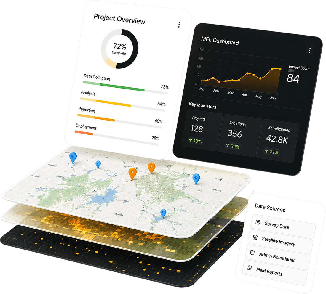
.jpg&w=3840&q=75) IMIS Platform
IMIS PlatformThe Municipal Service Delivery Challenge
Before IMIS, municipalities faced a set of common and systemic challenges:
- Fragmented datasets across sanitation, billing, and infrastructure services
- Manual and paper based FSM and billing workflows, leading to inefficiencies
- Limited digital channels for citizen engagement, reducing transparency
- Weak sanitation data governance frameworks
- Decision-making based on incomplete or outdated information
These constraints include limited operational efficiency, accountability, and effective urban planning—particularly in sanitation service delivery.
Comprehensive coverage across all municipal service areas
Fecal Sludge Management (FSM)
Digitized FSM service requests, scheduling, monitoring, and operational reporting.
Service Billing and Digital Payments
Integrated billing for sanitation and electricity services with secure online payment options.
Citizen Request Management
Structured workflows for service request submission, tracking, and resolution.
GIS Based Asset Mapping
Spatial mapping of households, roads, containment units, and sanitation infrastructure to support planning and monitoring.
Citizen Portal
Public facing access to service requests, bill payments, municipal announcements, and service updates.
Integrated Data and Governance Layer
Centralized municipal datasets enabling improved sanitation governance and reporting.
Hybrid Mobile and Web Architecture
Mobile applications for field operations and web based dashboards for municipal administration.
Capacity Building & Training
Hands-on training, data management guidance, and structured support across 12–13 municipalities - ensuring teams own and sustain the platform.
Human-centered Transformation
IMIS was designed as a service transformation tool, not merely a technology platform.
.jpg&w=3840&q=75)
For Citizens
- Online service requests and digital bill payments
- Real-time visibility into service status
- Increased transparency and improved access to municipal services
.jpg&w=3840&q=75)
For Municipal Teams
- Centralized dashboards replacing fragmented spreadsheets
- Improved coordination across departments
- Faster response times and clearer accountability
-1.jpg&w=3840&q=75)
For Governance and Oversight Bodies
- More reliable sanitation and service data
- Stronger monitoring and oversight capability
- Enhanced foundations for evidence-based planning and policy alignment
Evidence-based planning with city-wide spatial intelligence
A centralized GIS module integrates municipal datasets including households, roads, and containment units to enable spatial mapping and decision support
- 01Data LayersIncludes census-level field surveys and GIS data collection for households, roads, and sanitation infrastructure
- 02Advanced AnalysisFeatures spatial mapping to support municipal administration, planning, and monitoring of service delivery
- 03Decision SupportWeb-based dashboards provide real-time visibility and reliable data for oversight and policy alignment
.jpg&w=3840&q=75)
Built for scale and resilience
A robust, containerized stack ensures IMIS runs reliably across municipal environments with varying infrastructure maturity.
From Pilot City to Multi-Municipality Platform
IMIS was implemented using a phased, municipality centric approach, ensuring local ownership and long-term sustainability


Census-Level Field Survey & GIS Data Collection
Collected household, infrastructure, and sanitation data with GIS references to build a reliable municipal data foundation.
Municipality-Specific System Customization
Adapted IMIS modules, workflows, and service processes based on each municipality’s operational needs.
Field Data Integration into Live Dashboards
Converted collected field data into interactive dashboards for real-time monitoring, reporting, and decision-making.
Sanitation Data Governance Strengthening
Improved data standards, validation processes, and reporting structures to support better sanitation governance.
National Coordination with DPHE
Participated in technical coordination with DPHE to align IMIS implementation with national priorities and standards.
Training & Capacity Building Across Towns
Provided hands-on training to municipal teams so they could operate, manage, and sustain the platform independently.
Structured Documentation & Narrative Development
Prepared organized documentation, project narratives, and PDS inputs to support reporting, communication, and knowledge sharing.
Continuous Upgrades, Troubleshooting & Support
Delivered ongoing system improvements, issue resolution, and long-term technical support to keep IMIS operational and relevant.
Where IMIS is working
.jpg&w=3840&q=75)
Khulna City Corporation (KCC)
- Digital payment integration (EkPay)
- Wordwise access control and tax zoning
- Separation of FSM and Holding Tax systems
- Migration to the National Data Center (NDC)
.jpg&w=3840&q=75)
Bagerhat & Shibganj
- IMIS expansion and operational deployment
- GIS and payment module integration
- Training and reporting enhancements
.jpg&w=3840&q=75)
Lalmonirhat, Mymensingh, Kushtia, Benapole, Teknaf
- IMIS replication and customization
- GIS data integration
- Mobile deployment and digital payments